IMD issues red alert for Meghalaya: Heavy rainfall expected on May 27 and 28

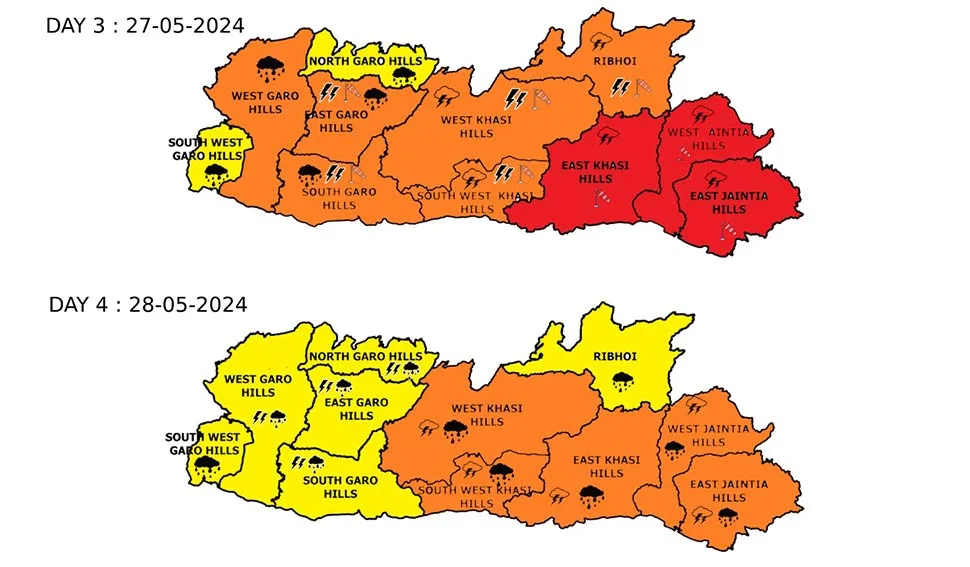
The Indian Meteorological Department (IMD) has issued a red alert for Meghalaya, forecasting very heavy to extremely heavy rainfall on May 27 and 28, 2024.
The IMD reported that a depression over the east-central Bay of Bengal has intensified into a deep depression, moving north-northeastward at a speed of 15 km/h over the past six hours. As of 05:30 IST on May 25, 2024, the system was centered over the east-central Bay of Bengal, approximately 490 km south of Khepupara in Bangladesh, 380 km south-southeast of the Sagar Islands in West Bengal, and 530 km south-southeast of Canning in West Bengal.
The system is expected to intensify further into a cyclonic storm within the next 12 hours and move nearly northward, becoming a severe cyclonic storm by the morning of May 26. It is likely to cross the coasts of Bangladesh and adjoining West Bengal between Sagar Island and Khepupara by midnight on May 26, bringing wind speeds of 110-120 km/h, with gusts up to 135 km/h.
As a result, widespread rainfall is anticipated over Meghalaya, with heavy to very heavy rainfall at many locations and isolated extremely heavy rainfall on May 27 and 28.
Forecast for Meghalaya:
May 25, 2024: Light to moderate rainfall with thunderstorms and lightning, along with gusty winds of 30-40 km/h, is expected at isolated places in Meghalaya.
May 26, 2024: Squally winds with speeds of 40-50 km/h, gusting to 60 km/h, are likely over many parts of Meghalaya. Heavy rainfall is expected across most of the region.
May 27, 2024: Heavy to very heavy rainfall is forecasted at many places, with isolated extremely heavy rainfall in some areas. Squally winds with speeds of 40-50 km/h, gusting to 60 km/h, are likely.
May 28, 2024: Moderate rainfall with thunderstorms and lightning is very likely at most locations. Heavy to very heavy rainfall with thunderstorms and lightning is expected at isolated places.
May 29, 2024: Moderate rainfall with thunderstorms and lightning is expected at most locations, with heavy to very heavy rainfall and thunderstorms at isolated places.
State Govt issues advisory:
The State Government urges residents to remain vigilant, ensure that emergency kits are prepared, and avoid unnecessary travel during this period and stay updated with the latest weather reports.
In light of the imminent weather threat, authorities emphasize the importance of preparedness. Standard Operating Procedures (SOPs) for cyclones provide essential guidelines for emergency responses. Here are some key do’s and don’ts to ensure safety:
DO’s:
Before cyclone:
- Ignore rumours, stay calm, and avoid panic.
- Keep mobile phones charged for connectivity and utilize SMS.
- Stay informed through radio broadcasts, television updates, and newspapers.
- Safeguard documents and valuables in waterproof containers.
- Secure your house, conduct necessary repairs, and prevent loose sharp objects.
- Ensure livestock safety by keeping animals untied.
During and After Cyclone:
If Indoors:
- Switch off electrical mains and gas connections.
- Keep doors and windows shut.
- If your house is unsafe, evacuate early before the cyclone’s onset.
- Listen to radio updates and rely only on official warnings.
- Consume boiled or chlorinated water for safety.
If Outdoors:
- Avoid entering damaged buildings.
- Watch out for broken electric poles, wires, and other hazards.
- Seek shelter in a safe location as soon as possible. Always consult ANM, ASHA, or the village First Aid team before taking any medicine.

Leave a Reply